We were not disappointed!
Days 0, 1 and 2
We flew from Tucson to Calgary via San Francisco and given our early morning start, we enjoyed breakfast at the San Francisco airport. We landed in Calgary in the middle of the afternoon

and began our two hour drive to Banff thanks to the Banff Airporter, a multiple times a day shuttle service. Our driver took us directly to our first night's destination, the Buffalo Mountain Lodge. Along the way, we noticed the haze (nearby fire at Octopus Mountain caused by a lightening strike) somewhat obscuring the view of downtown Calgary

but not the new housing developments noting homes for sale from $300,000 up

or the round hay bales, something I'd never seen before.

Enrique also photographed a local gasoline station and noticed, but it passed too quickly by, an Esso station, as well. Being an "oil company brat" who moved about every two and a half years during my childhood as my father was transferred overseas to various locations and increasing responsibility, I've always been interested in this landscape feature.

Soon we started seeing signs for Banff and early hints of the mountains to come. On the way up from San Francisco, I was overwhelmed by the number of mountain peaks clustered together that make up the Canadian Rockies - so overwhelmed, I simply gawked and forgot to pull out my camera.


We noticed signs to Lake Louise, too - our destination after a full day and a half in Banff


We arrived at Bear Mountain Lodge

and the carved wooden animals

and immediately adjourned to the dining room for an early dinner and bed. The room included a working fireplace and a wonderful deep footed bathtub, something I hope to add to our bathroom at home one of these days. Logistics for the trip required an arrival the day before, to be arranged by us, and a taxi the next morning to the Rimrock Resort Hotel

where we met up with the seventeen other members of our group and our two guides: Ken Brushett, a National Geographic Expert and Frances Dewart, an expedition leader. Our trip began from here.

We soon climbed aboard the two vans and headed out to the start of an interpretive walk led by Ken Brushett.

We strolled along taking in both the mountains and the valley as well as plenty of flowers and grasses.


Enrique captured a beautiful photo of grass


Here's a view of Sleeping Buffalo Mountain,

of a large, rather elegant looking place in the distance

and of flowers as well as of the Bow river we were to raft that afternoon.


 |
| Strawberry Blight |
But first, following our morning hike, we gathered in a park building for a luncheon feast


and then were treated to a presentation by Colleen Campbell, a local bear expert and researcher.

Her lecture was augmented a couple of evenings later when Enrique and I watched a television special about bears. Although apparently one might be able to distinguish between a defensive bear and a predatory bear and then take appropriate action (one lies down and plays dead or for the latter carries on in full defense of one's body), by the time the program closed, we decided that the best thing would be to avoid a bear in the first place. We were shocked later in the trip to observe at least ten people standing along the highway taking photos of a black bear with less than fifteen feet distance between them and the bear. If the bear had charged, someone -- including the bear who would probably join the many who are hit by a car each year -- would have been seriously injured.
After lunch we were ferried in the two vans, one which pulled our all-purpose trailer, to the Bow River for a scenic raft trip and suited up.


An enterprising young man stood on a nearby bank and called out for us to turn and wave. We were offered this great photo for a reasonable price following the ride:

The water really is that blue. More about this lake's color and others later.......
Our raftsman and guide, Kim, worked hard as he used the heavy oars to steer us down the river


during which we saw hoodoos on the shore

as well as fabulous views of the area -- Sleeping Buffalo Mountain,

the Bow River lined with tall pines, and periodic log jams.


We drove back to the Rimrock in time to observe a wedding on the lawn below the balcony.

Early the next morning, I opened the curtains to be greeted by the dawn.

Everyone met near the vans to prepare a bag lunch

and then were shuttled to Sunshine Meadows. To quote the trip description, "....we head to Sunshine Meadows, which features all the natural diversity that makes the Canadian Rockies so spectacular: alpine meadows strewn with wildflowers, glacial tarns, crystal-clear lakes and mountain peaks. The well-maintained trails, gorgeous scenery [somewhat dimmed by at times heavy smoke from the Octopus fire] and a wealth of wildlife make for some of the best hiking in the rockies. We meet up with our expert guide for an interpretive walk detailing the native flora and fauna of the region and the conservation efforts to preserve the area."
How I wish trails in the Tucson area were as well-maintained as those we found in the Banff/Jasper area or in N. California on Mt. Tam!!
Here are some photos, sometimes accompanied by captions:


 | |
| Hippy-On-A-Stick |
 | |||||
| Arnica |
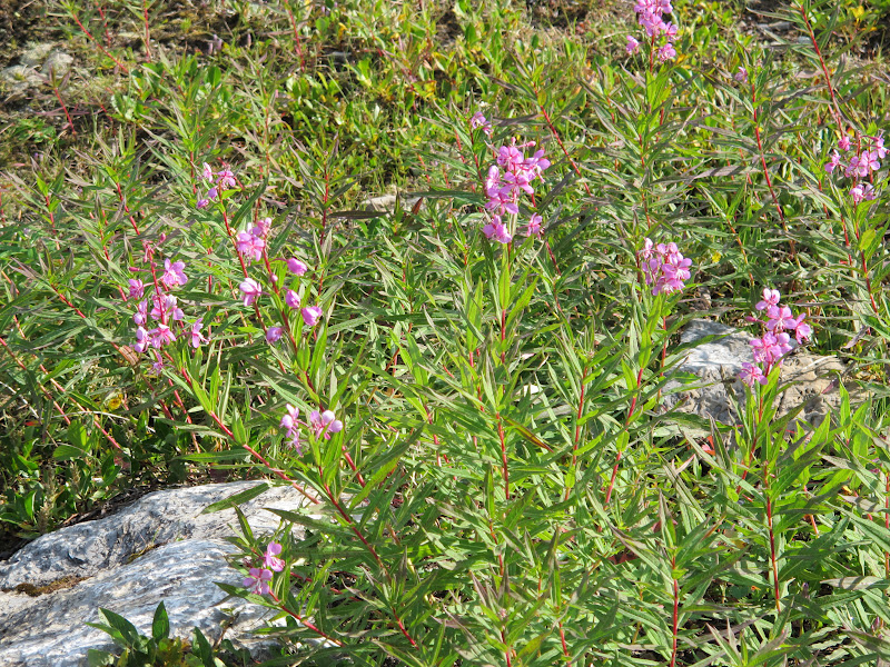 | ||||
| Alpine Fireweed |
 |
| Starting out |
On the way up the trail, I noticed that the ground was covered with wild strawberry plants....

You'll notice valerian blooming here, too. The scent of the blossoms is quite sweet but that of the oils is rather pungent and can be overwhelming.


We were disappointed by the amount of smoke in the air from the Octopus Mountain Fire. At times several of us were having trouble breathing and burning eyes. I imagine the following photo and others like it would have been even more splendid with the wonderful blue clear skies we encountered later in the week.

 |
| Need to identify this pretty flower; reminded me of tack stem but the latter has many more petals |

 |
| Enrique setting up |

 |
| Hazy smoke, beautiful lake |


Flowers and more flowers......


 |
| pink Indian Paint Brush! and white, as well |

 |
| Our other expedition leader, Fran |


 |
| Columbian Ground Squirrel |


Heading back the way we came .... and encountering this sign listing "Fatigue Pass". Very appropriate!
Following our 6+ mile hike, we drove on to Lake Louise with a view of Castle Mountain along the way......


At the Fairmont Chateau Lake Louise! Photos coming up soon of Lake Louise at Dawn....

 | ||
| The door to our room |
Time for dinner and an early turn in. Wonderful day!
Days 3 and 4
Lake Louise at Dawn, courtesy of Enrique who rose early to capture this incredible sequence of views on the shores of the lake.......


And, the view we had from our window......

[From this point on over the next several days, we visited many beautiful lakes and I need to add a caveat here that I may make a mistake when I identify them. I welcome feedback to keep this account accurate! or to provide names of flowers, e.g.]
Breakfast each morning at the Rimrock, the Chateau and later at Jasper Lodge was taken in a large dining room, usually with fantastic views of the surrounding mountains or lake(s). We opted for the breakfast buffet offerings which were many, ranging from eggs benedict to pancakes to pastries to cereal to yoghurt to fruit (and lots more in between) - all fresh and very tasty. We usually arrived about 7 a.m. to beat the rush and often joined others in our group, starting the day with cheerful conversation.
Each evening our guides, Ken and Fran, distributed sheets outlining the next day's activities with accurate time schedules along with suggestions for what to bring/wear. The first couple of days we all dressed for temperatures in the high 70's, for the area was experiencing an unusual heat wave. A good hat was a must as were walking shoes and especially a camera!!! Water to drink, of course.
From the brochure: "Once depicted on the Canadian twenty dollar bill, Moraine Lake is set in the stunning Valley of the Ten Peaks. After arriving, we take a short walk to the top of the Rockpile and marvel at the incredible views."


Moraine Lake, elevation 6,183 feet, is often described as the lesser known sister to Lake Louise. Apparently Grizzly Bears are sighted frequently in the area; however, we took only the short hike from the parking area to what's known as the "rockpile" to view this gorgeous lake and the amazing reflections.
Ken described the powerful action of the glaciers that pulverizes the mostly limestone rock in the area, reducing it to a fine talcum powder. It is this powder, suspended in the water of the lakes and streams, that provides the unusual colors. Here's Ken describing the churning mechanism that grinds the stone and pushes rock and other debris forward and outward.

On our way to this perch, we encountered a cute little pika that was busy gathering grasses and other food for its winter nest. S/he scurried back and forth across the trail and at one point ran between Enrique's feet.


 |
| Approaching the Takakkaw Falls |


 |
| Enrique enjoyed reacquainting himself with his camera |

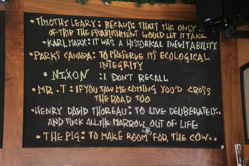
Lunch was a fun surprise, for we drove to the little hamlet of Field and were treated to delicious sandwiches at the Truffle Pigs

our entertainment being the flying pigs hanging from the ceiling as well as the proposed replies to the question, Why did the pig cross the road? written on the blackboards


After lunch, we were stunned by the power of the Kicking Horse River as it narrowed into a twisting funnel, churning through and then widening again to continue on.


Emerald Lake was next on our agenda, described in our bulletin as discovered by late 19th century mountaineer and adventurer Tom Wilson. Known not only for its beauty, the area is steeped in prehistoric history and revered by scientists and preservationists alike for its significant link to history and exquisitely preserved fossils. There was so much to observe, learn and absorb on this beautiful trek completely around the lake.


 | ||
| Emerald Lake Glacier Silt |
 | ||||
| The same silt, wet (suspended, the silt gives the lake its emerald color) |

We noticed lodges at many of the lakes we visited; most with few rooms, wonderful peace and quiet, amazing views.....
Off to the upper right along the ridge in this next photo is the Burgess Shale

Through additional work on the site, it was determined that the Burgess Shale included multiple fossil bearing layers of about 2 meters thick stacked 150 meters high and over 60,000 unique fossils have been found. The dominant fossils found are arthropods, but other fossils are found in great abundance, including worms, crinoids, sea cucumbers, chordates, and other organisms with no mineralized shell. Most fossils were found in underwater banks known as the phyllopod beds.
The Burgess fauna contains many fossils of soft bodied animals as well as those with hard parts. This is a tremendous opportunity for researchers because the soft bodied fossils are rarely found anywhere else -- such organisms are usually destroyed before they can be preserved as fossils. When an organism is completely soft, the body usually rots away before it can become fossilized. Hard parts are important because they are more easily preserved; they help the organism last long enough to become fossilized.


Tomorrow the glacier!!!!!
Day 4
When we started packing for this trip, and even before, I remarked that being wet, cold and miserable for a few days sounded awfully good after enduring what had become a hot, dry and miserable summer. We knew that we'd be walking on a glacier during our trip and we looked forward to a new experience for both of us. So, we focused on layering and made sure to bring along warm gloves. We also brought wool socks for our goretex hiking boots, the latter a must when we also learned we would be wearing crampons.
The intinerary for the day included driving to the Columbia Icefields (3 hours), a visit to the Columbia Icefields Interpretive Center and lunch while there, a walk on the Athabasca Glacier, and then the drive to Jasper Park Lodge. Along the way to the Icefields, we were to make stops at Bow Lake, Peyto Lake and Mistaya Canyon.
The drive up was breathtaking. Truth be told, Enrique slept much of the way in the van being worn out from long work days. So I spent a good deal of time, along with everyone else in our van, looking out the windows, taking photos, and gasping "look at that!"
Our first stop was near Bow Lake

and the start of the short walk over to Peyto Lake, the course all laid out on this sign:

Enrique captured a complete view of the lake in the next three photos, the first illustrating the water source (the glacier), the next the central part of this very long lake, and the third the "head" of it. We were challenged to think of what the lake might remind us of. Finally, a companion on the trip took our photo so we could say we truly were there.


We both enjoyed capturing reflections in the lakes we visited as well as simply enjoying the views.


 |
| Vehicle used to drive up the glacier should you not wish to walk it |
 |
| Enrique and Smoky the Bear |
 |
| Looking at the glacier from the Visitor's Center |
 |
| Meeting our guide, Bernard, and George, our guide dog |
 |
| We all wore crampons to get a better hold on the ice (and why hiking boots were essential) |
 |
| Ken, Peter (owner of the guide company), and Fran |
 |
| Looking across the rubble to the glacier |
 |
| Starting out; note the comparative size of the folks in the distance |
 |
| Constantly melting |
 |
| The power of the glacier and its contents scouring the rock |
 |
| A required water crossing ahead |
 |
| A close up of the ice of the glacier; you would not want to fall on this |
 |
| Looking back as we progress |
 |
| Looking forward..... for miles |
 |
| We were there |
 |
| Jumping for joy |
 |
| Heading back down watching the water course along |
 | ||||
| This water was boiling up from the base of the glacier.... underglacier melt? |
We had hoped to hike further up the glacier, but we had a long drive ahead of us still and plenty more to see along the way.......
Meanwhile, here's the traditional National Geographic Group Photo
